Andrew Gacom
Current Projects
The Conservancy is continually striving to enhance Ohio’s national park. Here’s what we’re working on now: Former Brandywine Golf Course.
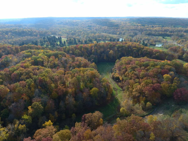
Photo by Jack McCormick
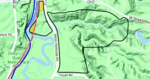
Property boundaries outlined in black
Former Brandywine Golf Course
Stay Updated on this Project – Sign up for Emails View Big Ideas & Concept Site Plan Presented on Feb. 24The Conservancy for Cuyahoga Valley National Park purchased the 213-acre property in September 2021 and transferred 198 acres to the National Park Service in 2022, retaining 15 acres for Conservancy programming.
The property sits on both sides of Akron-Peninsula Road and the Conservancy’s 15 acres are on the west (river) side of the property. We are forever grateful to our individual donors and private foundations for their incredibly generous gifts to secure the property and the five foundations that stepped forward with recoverable grants to help us bridge this purchase.
The property is currently closed to the public for safety reasons as remediation work is underway.
For more information about the project, please contact:
- Project Manager: Stacey Rusher, Park Projects Director, at srusher@forcvnp.org
- Donors: Sheryl Hoffman, Leadership Giving Director, at shoffman@forcvnp.org or 330.657.2909 ext. 143
- Media: Jennifer Bako, Marketing & Communications Director, at jbako@forcvnp.org
Site Remediation
Remediation work continues on the former Brandywine Golf Course. Over 60,000 tons of soil have been removed and confirmatory sampling and review is now underway. This data will help guide the remaining work on the project, which may include some additional soil removal followed by grading and reseeding. More will be known in the coming months.
See Frequently Asked Questions below for more on the remediation work.
Concept Work for Master Site Plan
In the fall of 2023, Studio Zewde, a landscape architecture, urban design, and public art practice based in New York City was hired to assist us with community engagement initiatives, site analysis and a framework for development. In addition to the National Park Service, Studio Zewde is working with two local firms: Biohabitats of Cleveland, an ecological and environmental consultant firm and Chagrin Valley Engineering (offices in Avon and Cleveland) as the civil engineer.
We welcome public input on this project and will provide opportunities for engagement sessions, special events as well as online surveys as this work progresses.
Currently, we are soliciting comments on the latest version of the plan presented to the public on February 24, 2024.
View Big Ideas & Concept Site Plan Presented on Feb. 24Please sign up for more information and updates on the project and/or check back here for details.
Stay Updated on this Project – Sign up for EmailsFrequently Asked Questions
What does remediation mean?
Remediation, in this case, means the removal of contaminated soil. Sampling on the property identified the presence of mercury in the shallow soil of the tee boxes, putting greens and some fairways. The use of fungicides and herbicides containing mercury dates to the 1950s and continued through the 1990s. These products were routinely applied multiple times per year using industry-standard practices and applicable product label information.
Mercury is a cumulative bioaccumulative toxin in wildlife, meaning that once ingested, mercury is not excreted but accumulates in fatty tissues and organs. Wildlife potentially affected include animals that are consumed by “top of the chain” predators (raptors, for example, that prey on shrews and voles).
What is the process and how much will it cost?
The process is called a dig and haul. A firm with a background in handling toxic waste will dig down and remove the soil. Further sampling and testing will indicate whether we must go a little deeper or broader or tell us that the area is clean enough to meet the required National Park Service standards for becoming a part of the national park. Mercury in this form is relatively immobile and there is no threat to humans on the property. The contaminated soil will be taken to a landfill equipped and approved to accept this kind of soil and it will be managed there in perpetuity.
The Conservancy was awarded a $4.5 million Brownfield Grant from the Ohio Department of Development for this work.
What happens after remediation is complete?
The property becomes part of the park! The Conservancy and National Park Service are working together to develop plans for the space, and both are very excited to give park visitors more access to the Cuyahoga River and the State of Ohio’s 13th official Water Trail. This designation identifies over 90 miles of the river with 24 current access points (and plans to increase with this property!) that encourage public use of waterways, promote ecotourism, and encourage conservation.
The National Park Service is looking at the conservation needs on the property. Plans include restoration of two streams that were channeled and buried to assist in creating fertile farmland and later a golf course. The park will monitor the site’s plants and animals, and take steps to protect and improve habitats.
What about plans for visitor amenities?
The Conservancy engaged PROS Consulting from Indianapolis, Indiana, the fall of 2021 to complete a market analysis report to help analyze and assess the possibilities for the acreage on the west side of Akron-Peninsula Road. Input from Conservancy board leadership, Conservancy staff, National Park Service staff, community stakeholders, and partners was used to help create a vision for this area. That vision includes: increasing opportunities for river access, supporting creative programming, and welcoming new, diverse audiences to the national park. It suggests possible amenities such as accessible trails, access to the river, beautiful river vistas from pavilions and nature play spaces, space for public programming, and a bridge connecting to the Towpath Trail.
The next step in the process is creating a conceptual master plan for the site. In the fall of 2023, Studio Zewde, a landscape architecture, urban design, and public art practice base in New York City was hired to assist us with community engagement initiatives, site analysis and a framework for development. In addition to the National Park Service, Studio Zewde is working with two local firms: Biohabitats of Cleveland, an ecological and environmental consultant firm and Chagrin Valley Engineering (offices in Avon and Cleveland) as the civil engineer.
How long will it take before the Master Concept Plan is finalized and implemented?
Planning takes time. Economic, environmental, cultural and social impacts have to be studied. A costing phase will guide prioritizing projects and creating a timeline for phasing in projects that require compliance approvals, permitting and zoning approvals, funding strategies, long-term maintenance plans to name just a few of the considerations. The key stakeholders: the Conservancy for Cuyahoga Valley National Park, the National Park Service and the Village of Peninsula each have their own processes and procedures they must follow before final approvals and implementation can begin. Some items can move quickly along the timeline and be ready for activation in 2-4 years, while others can take significantly longer. More will be known and shared as the work progresses.
How long before I can get out there and explore?
The Conservancy recognizes the excitement surrounding the new property. We know people are eager to explore and enjoy it and we want to share it as soon as we can. We are moving as fast as we can with a thoughtful and manageable approach to planning that will add depth and value to Cuyahoga Valley National Park for generations to come.
We look forward to sharing more with you after we complete the remediation and next phase of planning. We are grateful for your patience and support!
Contact Us
Tel 330.657.2909
Fax 330.657.2328
1403 West Hines Hill Road
Peninsula, Ohio 44264

Charity Navigator is America’s premier independent charity evaluator. Click on the logo to review our four star rating.
![]()
Visit Our National Park
Corporate Partners
![]()
© 2025 Conservancy for Cuyahoga Valley National Park