Wetmore, Tabletop & Langes Run Trails
At A Glance
Distance & Difficulty
Wetmore Trail: 4.5 miles, moderate
Tabletop Trail: .75 miles, easy to moderate
Langes Run: 3.5 miles, moderate to difficult
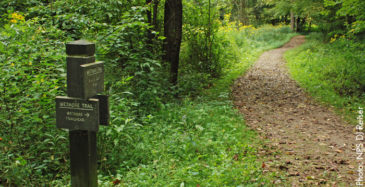
Hikers, runners, and equestrians who love a challenge and a little isolation will thrive on this trail. Wetmore NPS Map
The Wetmore Trail (which includes Tabletop Trail and Langes Run Trail) has been a bit “incomplete” until recently. Back in 2003, heavy flood damage closed nearly a mile of the trail and a fairly comprehensive restoration effort by the Conservancy was necessary to bring the trail back to hiking and equestrian shape. A 2013 Trail Management Plan was executed and pulled the section back in line with the trail corridor, which is anchored by the moderate Wetmore and Langes Trail loops. The whole Wetmore area is comprised of about 9 miles in total, but is part of 20 miles of equestrian trails that fortify this region of the CVNP—made up of old farmers paths and logging roads.
Directions
From Peninsula, take Peninsula Rd. south to Akron Peninsula Rd., then to Wetmore Rd. (approximately 1.5 miles), then turn left on Wetmore Rd. In approximately a half-mile, parking will be visible from the road.
What Makes it Great
Versatility. This is a multi-use section of the CVNP, and hikers, snowshoe enthusiasts, and equestrians all get major use of the trail system here. The trail is irregular, somewhat “mixed-media,” with gravel, clay, dirt, hills, and slopes, and is narrow in spots. Be sure to yield to bridal-equestrian traffic: they have the right of way! What’s more, irregular trails and changing elevation offer a moderate challenge that vary with weather and various seasonal conditions.
Who Is Going to Love It
Hikers, snowshoe fans, horseback riders and the like are bound to love the adaptable, multipurpose terrain here. This trail system has a tendency to never be the same twice. Several visits can yield completely different traction experiences.
Photo Gallery
Contact Us
Tel 330.657.2909
Fax 330.657.2328
1403 West Hines Hill Road
Peninsula, Ohio 44264

Charity Navigator is America’s premier independent charity evaluator. Click on the logo to review our four star rating.
![]()

Visit Our National Park
Corporate Partners
![]()

© 2025 Conservancy for Cuyahoga Valley National Park